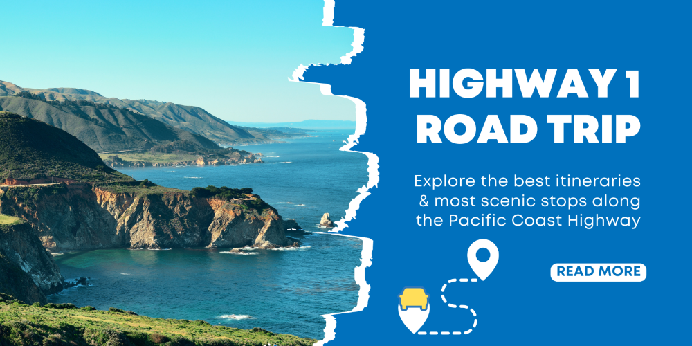
The Pacific Coast Highway (PCH), officially California State Route 1, is a 656-mile masterpiece weaving through cliffs, redwoods, and seaside towns. Dubbed “the world’s most scenic drive,” it draws millions seeking rugged coastline, wildlife encounters, and iconic landmarks like Big Sur’s Bixby Bridge.
👉Explore the scenic HIGHWAY 1 BUS TOURS
How to Plan a West Coast Road Trip Along Highway 1
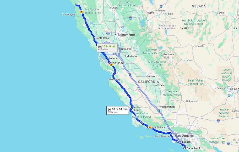
Officially, California State Route 1 runs from its southern starting point in Dana Point, Orange County, and stretches 656 miles to its northern end point in Leggett, Mendocino County. However, the most celebrated and scenic portion – the classic drive – is the roughly 460-mile stretch between the metropolitan areas of Los Angeles and San Francisco.
What is the prettiest part of the Pacific Coast Highway?
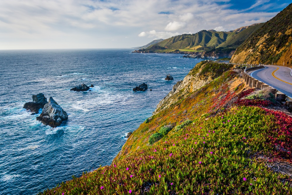
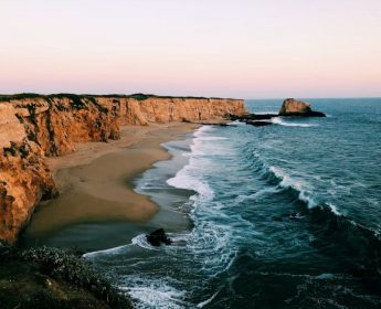
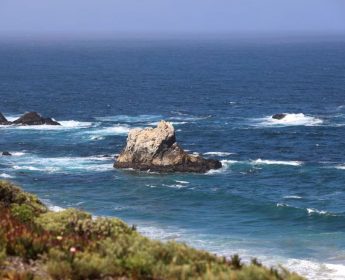
Universally, the stretch through Big Sur is acclaimed as the most beautiful and dramatic part of the Pacific Coast Highway. This roughly 90-mile segment, which you will reach after San Simeon and before Carmel, is where the highway twists and turns along steep cliffs, offering unparalleled views of the rugged coastline, hidden coves, and crashing surf below. It is the heart and soul of the journey.
What is the best time of year to travel the Highway 1?
The ideal times to drive Highway 1 are during the spring (April to June) and fall (September to October). During these months, you’ll enjoy pleasant, mild weather, fewer crowds than the peak summer season, and a better chance of clear, fog-free days. Spring offers blooming wildflowers, while autumn provides some of the clearest skies of the year.
How many days to travel the Pacific Coast Highway?
While you could technically rush the drive between Los Angeles and San Francisco in two days, you would miss the essence of the experience. To truly savor the views, explore the towns, and enjoy a few hikes, plan for a minimum of five days. A seven-day trip allows for a more relaxed pace, with ample time for spontaneous discoveries and deeper exploration.
What is the best way to travel the Highway 1?
There are two schools of thought on this. Many advocate for driving from north to south because it places you in the outer lane, offering easier pull-offs and slightly better ocean views. However, driving south to north has its own advantages. You will be on the “inside” lane, which can feel safer and more comfortable for drivers nervous about the steep cliff edges, especially through Big Sur.
Best Places to Stop on the Pacific Coast Highway
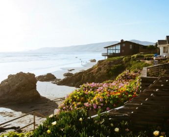
The magic of traveling the Pacific Coast Highway lies in its incredible stops. Each one offers a unique slice of California’s coastal charm. We’ll journey from north to south, hitting 20 of the most essential and breathtaking locations that make this road trip unforgettable.
Stop 1: Half Moon Bay
Just south of San Francisco, Half Moon Bay offers the first proper taste of the coastal serenity you’ll be chasing. The town itself has a charming Main Street filled with local shops and eateries. For a truly scenic introduction, take a walk along the Coastal Trail near the Ritz-Carlton, where you can watch waves crash against the rocky shoreline and feel the cool Pacific spray. It’s the perfect place to decompress from the city and ease into the rhythm of the coast.
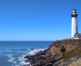 Stop 2: Pigeon Point Light Station
You can’t miss this towering beacon. As one of the tallest lighthouses on the West Coast, Pigeon Point Light Station State Historic Park is a stunning piece of maritime history. While the tower itself is currently closed for entry, the grounds are open and offer fantastic photo opportunities. The panoramic view of the ocean from the observation deck is worth the stop alone. It’s a powerful reminder of the raw, untamed nature of this coastline that mariners have navigated for centuries.
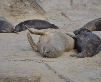 Stop 3: Año Nuevo State Park
This is a stop for wildlife lovers. Año Nuevo State Park is home to the world’s largest mainland breeding colony for northern elephant seals. From December through March, you can join a guided walk to see these massive, fascinating creatures during their dramatic birthing and mating season. Hearing the deep, guttural calls of the males and watching the pups is a raw and powerful wildlife experience unlike any other on the coast.
 Stop 4: Santa Cruz
Embrace the classic California beach vibe in Santa Cruz. Walk the iconic Santa Cruz Wharf, listening to the barking sea lions that have made it their home, and then head to the adjacent Santa Cruz Beach Boardwalk for a dose of nostalgic fun with its classic wooden roller coaster. The energy here is infectious, a sun-drenched blend of surf culture and old-school amusement park charm.
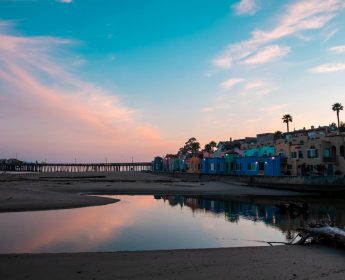 Stop 5: Capitola Village
Just a short drive from Santa Cruz, Capitola Village feels like a small European seaside resort teleported to the California coast. Famous for its brightly colored, Venetian-style condominiums lining the shore, this is a fantastic spot for a leisurely stroll. Grab a coffee, walk out onto the wharf, and enjoy the view of this uniquely vibrant and photogenic little town.
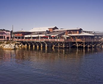 Stop 6: Monterey
Monterey is steeped in history and marine life. Spend a few hours exploring the revitalized Cannery Row, made famous by John Steinbeck, now home to shops and restaurants. Don’t miss Old Fisherman’s Wharf, where you can sample clam chowder and book whale-watching tours. The crown jewel, however, is the world-renowned Monterey Bay Aquarium, a must-visit for its stunning exhibits on the rich marine ecosystem of the bay.
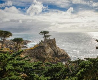 Stop 7: 17-Mile Drive
Winding through the exclusive Pebble Beach community, the 17-Mile Drive is a scenic detour worth the entrance fee. You’ll see perfectly manicured golf courses, stunning mansions, and dramatic coastal views. The most famous stop is the Lone Cypress, a solitary tree that has clung to its rocky perch for over 250 years, becoming a symbol of resilience and one of California’s most photographed landmarks.
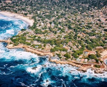 Stop 8: Carmel-by-the-Sea
Carmel is a fairytale village come to life. With its charming, European-style cottages, hidden courtyards, high-end art galleries, and a stunning white-sand beach, this town is pure magic. Park the car and explore on foot; its grid-free layout is part of the fun. It’s an incredibly romantic and picturesque place to spend an afternoon or an overnight stay.
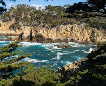 Stop 9: Point Lobos State Natural Reserve
Often called the “crown jewel” of the State Parks system, Point Lobos is a place of staggering natural beauty. The network of hiking trails here leads you through rare cypress groves and along dramatic sea cliffs. Hike the Sea Lion Point Trail to hear the barks of offshore sea lions and keep your eyes peeled for sea otters playing in the kelp forests below. The water is so clear and vibrant, it’s easy to see why this is a protected ecological reserve.
 Stop 10: Garrapata State Park
Just as you’re entering the Big Sur region, Garrapata State Park offers a stunning preview of what’s to come. Pull over near Soberanes Point for incredible views up and down the rugged coastline. A short hike on the headland trails will reward you with panoramic vistas and, in the spring, a spectacular display of wildflowers. It’s a less-crowded alternative to other Big Sur parks but every bit as beautiful.
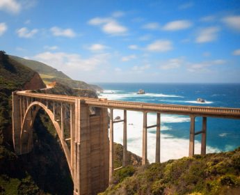 Stop 11: Bixby Creek Bridge
This is it, the postcard shot. Bixby Bridge is one of the most iconic and photographed bridges in California. Driving north to south gives you the perfect approach. Pull into the Castle Rock Viewpoint on the north side of the bridge for the classic, sweeping view. There’s a sense of awe as you stand there, looking at this architectural marvel gracefully spanning the deep canyon, a perfect marriage of human engineering and natural splendor.
 Stop 12: Pfeiffer Big Sur State Park
Known as a “mini Yosemite,” this park offers a different side of Big Sur’s beauty. Here, the focus shifts from the coast to the forested landscape inland. Hike amongst majestic redwood groves along the Big Sur River. The Valley View Trail offers a lovely, relatively easy hike with a rewarding view of the valley. It’s a peaceful, shaded retreat from the sunny coastline.
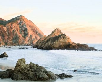
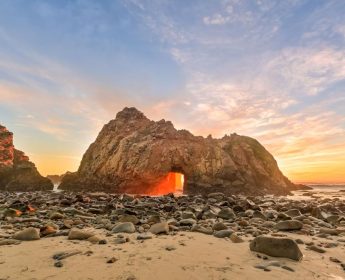 Stop 13: Pfeiffer Beach
Finding Pfeiffer Beach is part of the adventure. Look for the unmarked, sharp turn onto the narrow Sycamore Canyon Road. Your reward is a breathtaking beach famous for Keyhole Rock, a massive sea stack with a natural arch that waves crash through. At low tide, look for patches of unique purple sand, colored by manganese garnet deposits washing down from the hillsides.
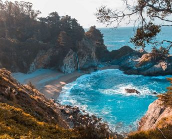 Stop 14: Julia Pfeiffer Burns State Park (McWay Falls)
This stop is home to one of Big Sur’s most enchanting sights: McWay Falls. An 80-foot waterfall that cascades directly onto a pristine, inaccessible beach. The Overlook Trail is a very short and easy walk from the road, leading you to the viewpoint. Note: Check for trail closures as repair work can sometimes limit access, but even the view from the highway shoulder is breathtaking.
 Stop 15: Ragged Point
Often called the “Gateway to Big Sur,” Ragged Point is a welcome stop after the demanding, winding roads of the southern Big Sur coast. The Ragged Point Inn has a restaurant and gift shop, but the real draw is the “Million Dollar View” from behind the inn. There’s also a steep but rewarding cliffside trail that takes you down to a black sand beach.
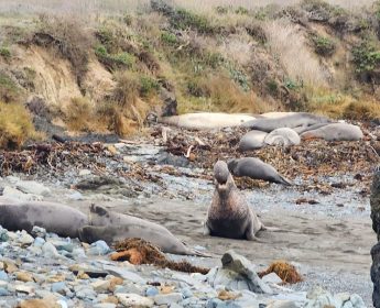 Stop 16: Elephant Seal Vista Point
A few miles north of San Simeon, you’ll find a spectacle of nature you won’t soon forget. The Piedras Blancas rookery is home to thousands of elephant seals. A dedicated boardwalk allows you to safely view these massive marine mammals as they lounge, fight, and care for their young on the beach. The peak season is from December to May, but seals are present year-round.
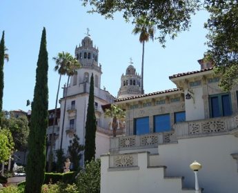 Stop 17: Hearst Castle
Perched high above the coastline, Hearst Castle is a lavish and opulent estate built by newspaper magnate William Randolph Hearst. The sheer scale and grandeur of the art, architecture, and pools are astounding. You must book a tour in advance to visit, with the Grand Rooms Tour being a popular choice for first-time visitors.
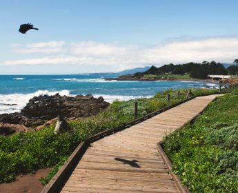 Stop 18: Cambria and Moonstone Beach
Cambria is a delightful artist-colony town with a charming village feel, perfect for an overnight stay. Its most lovely feature is the Moonstone Beach Boardwalk, a mile-long wooden path that meanders along the bluffs. It’s the perfect place for a sunset stroll, searching for the smooth, translucent “moonstones” that wash up on the shore.
 Stop 19: Morro Bay
You’ll know you’ve arrived in Morro Bay when you see the colossal Morro Rock, an ancient volcanic plug that dominates the harbor. This is a fantastic place for wildlife viewing. Walk along the Embarcadero and look for sea otters floating on their backs in the calm bay waters. You can also rent kayaks for an even closer (but respectful) look.
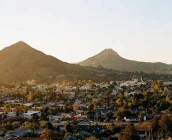 Stop 20: San Luis Obispo
“SLO” offers a vibrant, friendly atmosphere with its bustling downtown. A must-see is the quirky Bubblegum Alley, a narrow lane whose walls are covered in chewed gum. On Thursday nights, the city hosts a fantastic Farmers’ Market that takes over several blocks with food stalls, live music, and local vendors. It’s a fun, lively end cap before the final stretch to Southern California.
West Coast Highway 1 Road Trip Itinerary
Here are three suggested itineraries to help you structure your trip based on how much time you have.
The 3-Day Express (Focus on Big Sur)
Day 1: Monterey to Cambria.
Start in Monterey, explore Carmel, then drive the core Big Sur coast. Stop at Point Lobos, Bixby Bridge, Pfeiffer Beach, and McWay Falls. Overnight in Cambria.
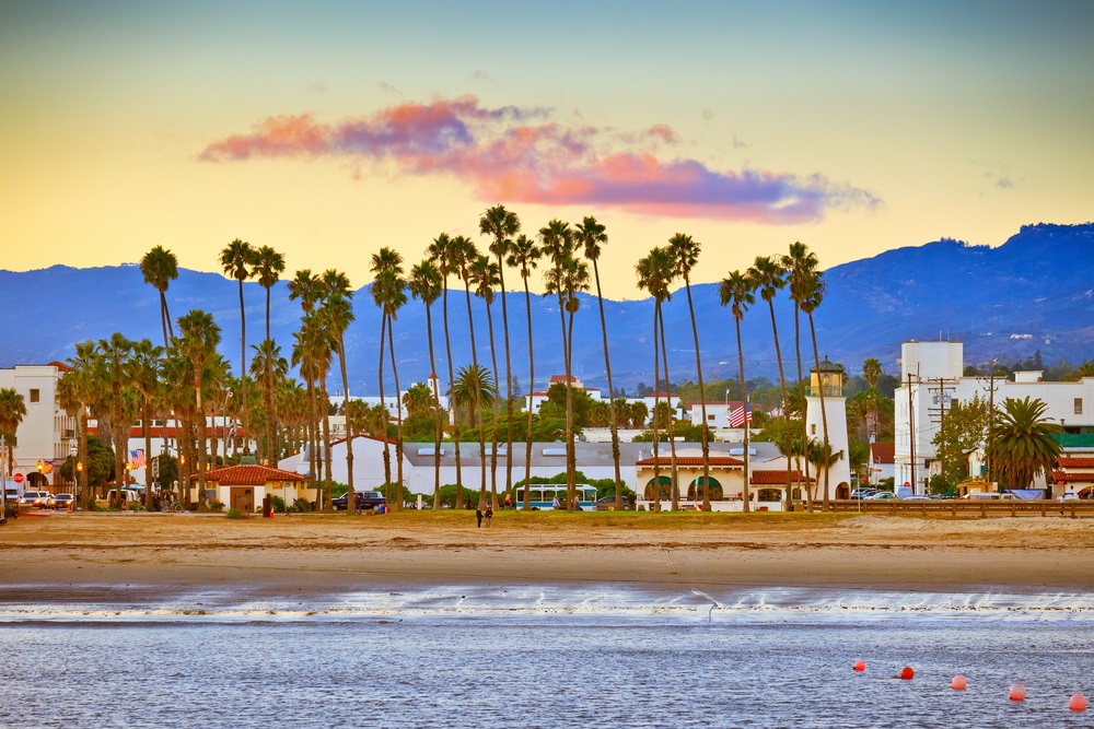
Day 2: Cambria to Santa Barbara.
Visit the Elephant Seals and Hearst Castle (book in advance), then see Morro Rock. Drive south to the charming Danish village of Solvang before ending in Santa Barbara.
Day 3: Santa Barbara to Los Angeles.
Enjoy Santa Barbara’s Stearns Wharf and Funk Zone in the morning before making the final scenic drive down to the LA area, perhaps ending at the Santa Monica Pier.

The 5-Day Classic Journey (San Francisco to Los Angeles)
Day 1: San Francisco to Monterey.
Drive south, stopping in Half Moon Bay and Santa Cruz before arriving in Monterey.
Day 2: Monterey & Carmel.
Spend the day exploring the Monterey Bay Aquarium, 17-Mile Drive, and the charming village of Carmel-by-the-Sea.
Day 3: The Heart of Big Sur.
This is the main event. Drive from Carmel to Cambria, taking your time at all the major Big Sur stops: Point Lobos, Bixby Bridge, Pfeiffer Big Sur State Park, Pfeiffer Beach, McWay Falls, and Ragged Point.
Day 4: Castles, Seals, and SLO.
Visit Hearst Castle and the Elephant Seal Vista Point. See Morro Rock and explore downtown San Luis Obispo. Overnight in Pismo Beach or SLO.
Day 5: Pismo Beach to Los Angeles.
See the Monarch Butterfly Grove in Pismo Beach (in season), visit Solvang, and enjoy Santa Barbara before completing your journey in Los Angeles.

The 7-Day Ultimate Exploration (More Depth and Relaxation)
Day 1: San Francisco to Santa Cruz.
Day 2: Santa Cruz to Monterey/Carmel.
Day 3: Exploring Monterey & Carmel.
Day 4: Big Sur (Part 1).
Drive from Carmel to a hotel in the Big Sur area itself (like Big Sur Lodge or a rustic inn), allowing you to explore the northern part without rushing.
Day 5: Big Sur (Part 2) & Cambria.
Explore the southern part of Big Sur before driving to Cambria for the night.
Day 6: Cambria to Santa Barbara.
A full day for Hearst Castle, the seals, Morro Bay, SLO, and Solvang.
Day 7: Santa Barbara & Los Angeles.
A relaxing morning in Santa Barbara before the final drive.
Frequently Asked Questions
Is it better to drive Highway 1 north or south?
This depends on your preference. Driving north to south (SF to LA) puts you on the ocean side for slightly easier pull-offs into scenic viewpoints. However, driving south to north (LA to SF) places you on the inner lane, which can feel more secure for those wary of heights. Both directions are fantastic.
Is driving the Pacific Coast Highway difficult or scary?
The section through Big Sur can be challenging. The road is two lanes, narrow in places, and features sharp turns with steep drop-offs. If you are a nervous driver, the south-to-north direction might feel more comfortable as you’ll be on the inside lane. Regardless of direction, drive slowly, stay alert, use the pullouts to let faster traffic pass, and avoid driving it at night if you are inexperienced with such roads.
Are there parts of Highway 1 to avoid?
The main concern is road closures. The Big Sur coast is prone to rockslides, especially after heavy rains, which can close sections of the highway for long periods. ALWAYS check the Caltrans website for the latest road conditions before your trip. Detours can add hours to your drive.
How much does a Pacific Coast Highway trip cost?
A reasonable budget is around $200-$250 per person, per day, covering lodging, gas, and food. Gas is expensive in California. Accommodation can range from budget motels to luxury resorts. A 7-day trip for two people could cost around $3,000, not including flights or car rentals.
Do I need to book accommodations in advance?
Yes, it is highly recommended, especially during peak seasons (spring, summer, fall). Popular towns like Monterey, Carmel, and Cambria can book up months in advance. Lodging within Big Sur is very limited and often requires booking a year out.
What should I pack for a Highway 1 road trip?
Layers are essential. Coastal weather can change from foggy and cool to warm and sunny in a matter of hours. Pack T-shirts, sweaters, and a windproof/water-resistant jacket. Other must-haves include comfortable walking shoes, sunscreen, sunglasses, a camera, a portable phone charger, and downloaded offline maps, as cell service is non-existent in large parts of Big Sur.
There’s a reason why traveling the Pacific Coast Highway is an iconic American dream. It’s the thrill of hugging dramatic cliffs as the Santa Lucia Mountains plunge into the turquoise Pacific, the scent of salt and eucalyptus on the breeze, and the freedom of the open road stretching before you.


There are no comments.